Newbridge to Oxford
Tuesday 11 April 2017

To our relief, the fourth day of our journey was to be the last when we would have to carry all of our camping equipment. Heading back to my girlfriend's flat in Oxford at the end of the day and having made alternative arrangements for accommodation everywhere we had planned to camp, we could leave plenty of things behind and make our rucksacks considerably lighter. With just three days done and twelve to go, that was a very appealing thought as we set out from Newbridge.
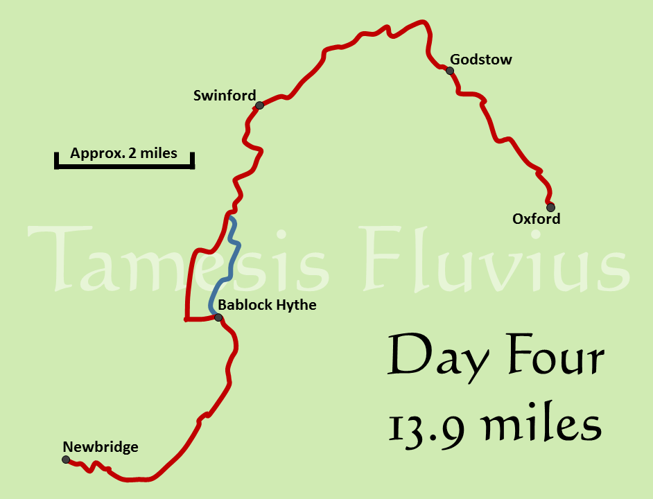
Although it was shorter than Day Three, the final day with the extra weight to carry was still a challenging task though as it was virtually fourteen miles from Newbridge to the finishing point in Oxford and then a little more to get to our bus stop. Despite ending with a trek into the first city along the river and being considerably less isolated on the way than the previous section of the path, this stage still for the most part had an extremely rural feel to it. There was however an inescapable sense that the river was starting to change in character and becoming noticeably busier.
The Thames Path runs right through the grounds of The Rose Revived pub, meaning that after enjoying their excellent breakfast we were able to be back on the route in almost no time at all. The day began by passing the trees which dip almost into the river alongside Newbridge, before heading off along the northern bank for another section of tranquil riverside walking. Apart from a few farm buildings and the occasional boat house, the first part of the day was almost as isolated as the previous day's walking had been and the path clung to every turn in the river just as tightly. Unlike Day Three however, there was a significant section away from the river on this part of the route and after some three and a half miles we reached the Ferryman Inn at Bablock Hythe and turned left away from the river, passing by the edge of the adjoining caravan park.
Thankfully there is only a short section of road walking to be done before the path turns away through farmland, passing through fields of sheep and lambs adjoining both Pimm Farm and Tawney's Farm. After finding a shady spot in the corner of one field to take a brief rest, we soon came to the bridleway which runs down from the village of Stanton Harcourt. Turning away from the village, we followed that track for a short time and then headed through several more fields, after which the path soon returns to the banks of the Thames. Here we passed by an abandoned rowing boat in a narrow channel off the main river, which clearly had been there for some considerable time, before reaching Pinkhill Lock and the first crossing of the day, which took us back to the southern bank.
Having crossed the weir and the lock itself, the path soon brought us to another very brief section of road walking along the B4044, which links Oxford to the nearby village of Eynsham. Very quickly returning to the Thames via the entrance to a boat yard, we headed through several more fields having set ourselves the target of reaching Swinford Bridge in time for our lunch stop. The bridge soon came into view, carrying the same road which we had briefly walked alongside. To get to it we had to cross one field marked by warnings of a bull, but there was no sign of one as far as we could see. We found a perfect spot for lunch in the shade of the bridge, which is one of only two upstream of London where a toll is still charged to cross - in this case, the significant sum of five pence for a car!
Heading onwards from Swinford, the Thames Path briefly shares its route with the Oxford Greenbelt Way, a sure sign that the city itself is not far away. We passed briefly through the edge of Wytham Great Wood before returning to open fields, one of them populated by a large herd of cows who came across to investigate us. Although the path still feels quite rural at this stage, the signs of increasing population are in evidence as we could soon hear the sound of cars on the A40, which passes near to the opposite bank carrying traffic between Oxford and Witney. After passing by a couple of tight meanders in the river, where again most people clearly chose to cut the corner rather than follow the riverbank precisely, we came to King's Lock, the most northerly point on the Thames and a good opportunity for another break before the final stretch towards Oxford.
Another long Environment Agency track runs down to King's Lock and we were forced to make more use of it than expected as there were some marked sections of the path here that were significantly overgrown with trees and clearly had not received any attention for some years. The rumble of traffic was louder here as we approached the dual carriageway A34, which the path passes underneath, before crossing over a thankfully much smaller road and reaching the remains of Godstow Abbey. The Abbey dates from the 12th century but having become a private home after the dissolution of the monasteries, has been in ruins since the Civil War. After passing the Abbey, the river becomes noticeably wider and straighter in its course, soon bringing evidence of something for which Oxford is renowned - rowing.
Passing by the Port Meadow on the opposite bank, where the right to graze animals was recorded in the Domesday Book, we saw several crews out training on the river, usually accompanied by a motorboat from which a coach was shouting out instructions through a megaphone. Here there were significantly more people using the path, people out for a short walk from Oxford, while on the other side of the Thames a number of horses were drinking from the river. With the skyline of Oxford clearly in view, the Thames Path eventually moves onto the long, thin Fiddler's Island, which runs between the Thames and the Castle Mill Stream. The path stays on the island for its entire length, before returning to the 'northern' bank, which here is actually due east of the river. Our fourth day of walking ended with a brief diversion around a section of the bank near to some building work, before leaving the path at Osney Bridge and heading to the flat where we could finally leave our camping equipment behind.


