Oxford to Abingdon
Wednesday 12 April 2017

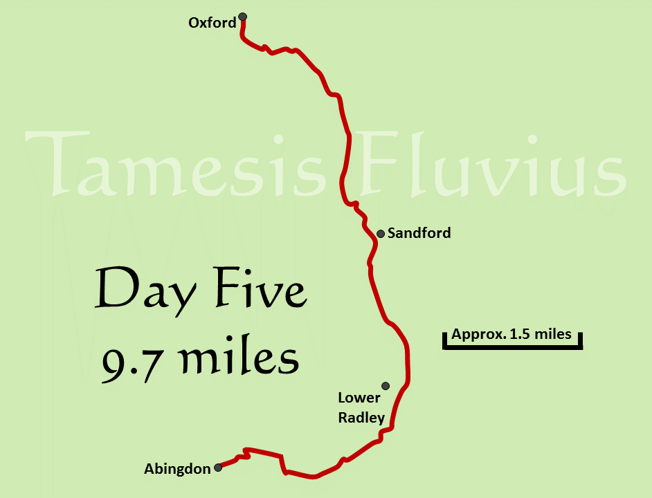
After covering more than thirty miles in the previous two days, it was not just the fact of leaving our camping equipment behind in Oxford that made Day Five seem like a much simpler challenge, as at just under ten miles it was easily the shortest section of the path we had faced so far. For most of the day the route runs quite close to the railway line which links Oxford and Didcot Parkway, so in addition to the noise of road traffic there was the regular sound of passing trains to accompany us on the journey.
The day's route ran mostly north to south and could be divided into two distinct sections, firstly the early miles through the suburbs of Oxford and then the more rural section which took us to Abingdon. With Abingdon having formerly been the county town of Berkshire, it is worth noting that this section of the river, like the previous day and indeed the next, would at one time have seen us switching counties on a regular basis as the Thames formed the border between Berkshire and Oxfordshire. Since the 1970s however, both banks of the river are very much in Oxfordshire.
After a bus journey and a short walk through the city centre had taken us back to Osney Bridge, we picked up exactly where we had left off the previous evening and began the journey southwards across a number of footbridges which cross various channels alongside the Thames itself. The route here passes beneath the railway line for the first time and eventually emerges at Folly Bridge, after which there are wonderful views of Christ Church Meadow on the opposite bank. The Meadow is one of my girlfriend's favourite spots and we have walked there a number of times, but this was the first time I had seen it from the other side of the river. Oxford's rowing tradition is again much in evidence as you pass many college boathouses on the way out of the city, with once again a number of crews out training early in the morning.
After a brief rest stop at Iffley Lock, we passed by an abandoned boat with a notice warning of its imminent removal, before heading under both the Oxford ring road and a branch line of the railway which now serves only the assembly plant for Minis at Cowley. From that point onwards the day took on a somewhat more rural feel again, with plenty of geese and swans for company along the river bank. Heading towards Sandford Lock, I was aware of the warning which I had read on the Thames Path website before leaving home, which indicated that there had been diversions in recent times due to work in the area. However, when we reached that area we were pleased to see that the only restrictions now were on nearby fields and no longer affected the path itself.
We headed on to the island of Fiddler's Elbow, which separates the navigable channel from the route leading to the 'Sandford Lasher' pool and its accompanying weir, which we could hear roaring just out of sight.After crossing a couple more islands, the path soon returned us to the western (southern) bank where we would remain until the final approach to Abingdon. The next mile or so of the path is a long, straight section of river, where boats travelling up and down stream were a regular sight. The boats become noticeably larger below Oxford, as those which cannot pass under the lower bridges are not seen further up. Large boathouses are also now an increasingly common site, both those connected with the university and those belonging to private rowing clubs.
Despite the traffic on the A4074, visible in places almost a mile away from the opposite bank, it still feels quite isolated here as there are plenty of trees shielding the path from the outside world. Indeed, the highlight of this section is probably those parts of the path where the trees and hedges on both sides almost join to form an arch above your head. After passing by the impressive Nuneham House on the opposite bank and a couple of very large farmhouses on our side of the river, we reached the Nuneham Railway Bridge at just about the perfect time to stop for lunch, knowing that already we were not far from our destination. We took a break almost right under the bridge, which was a good spot for shade but not the quietest when a train thundered overhead!
Accompanied by the sound of quad bikes racing around a track on the other side of the river, we began the final stretch of Day Five towards Abingdon. This part of the path was again well sheltered by trees on both sides, with glimpses of the river at times having to be snatched through gaps in the branches. As Abingdon approaches, the Thames Path diverts just briefly to pass around a small channel which flows into the river, before emerging from the trees alongside Abingdon Weir. Here we crossed the Thames again, over what was comfortably the longest bridge which we had so far encountered along a weir. Crossing Abingdon Lock as well, it was also the first time that we had passed by a lock at the moment it was in use.
We were now back on what is, in relation to the river as a whole, the northern bank although here it is actually on the southern side of the Thames as it briefly flows westwards. The town was by now clearly in view up ahead, with the river splitting in two as it passes under Abingdon Bridge. We walked under the bridge and then left the path behind, heading into the town towards our accommodation, although that still left us with around a mile and a quarter to walk as we were staying with an Airbnb host at the very southern end of the town. It was worth the extra walk though, as our room gave us a nice view overlooking Abingdon Marina as well as a welcome rest.


